It’s been 27 years since a hurricane last hit Cape Cod.
And though that storm, Hurricane Bob, caused a substantial amount of damage, it was “not much of a test, because it was only a fairly minor category 2 storm,” said Jeff Donnelly, who studies hurricanes at the Woods Hole Oceanographic Institution.
The last time the Cape was truly tested by a hurricane, according to Donnelly, the region looked almost nothing like it does today.
This is the first part in our 5-part series, "Are We Ready: Hurricane Preparedness on Cape Cod and the Islands." The series is a collaboration with the Cape Cod Times.
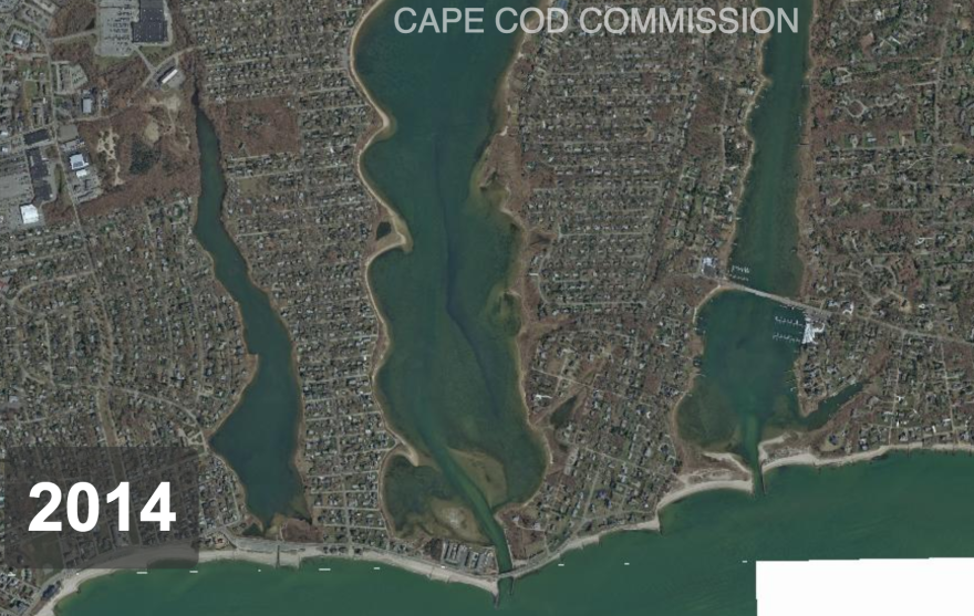
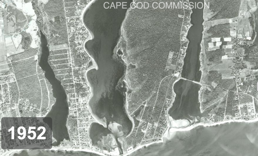
“Right in the middle of the 20th century, we see this dramatic uptick in the population of Cape Cod,” Donnelly said. “So now we’re up at over 250,000, whereas before we were at about 25,000.”
Since that population boom – which, inevitably, brought with it a building boom – there has been exactly one hurricane: Bob.
Effectively, Donnelly said, “we remain untested in terms of a really intense storm with this level of coastal development.”
One of the best places to see that level of coastal development is on a thin little finger of land in East Falmouth that’s sandwiched between two salt ponds – Green Pond and Great Pond.

On a hot, sunny day, right in the middle of hurricane season, Greg Berman, a coastal processes specialist with Woods Hole Sea Grant and the Cape Cod Cooperative Extension, was standing on the corner of Menauhant Road and Woodland Road, flood map in hand.
“Right now,” he said, “we’re in the flood zone.”
The only way he can tell that is by consulting that map he made of this neighborhood.
On this corner, the ocean is more than half a mile away, out of view. All around are tree-lined streets and modest, single-family homes that look like they could be almost anywhere in suburban Massachusetts.
But in a 100-year storm – a storm that has a one percent chance of happening in any given year – all of these homes would “pretty much be at the shoreline of Nantucket Sound,” Berman said.
After consulting the map, Berman walks just a couple of blocks down Menauhant Road, toward the ocean, before stopping again.
Already, the hypothetical floodwaters have risen fast. Now, he said, “we’re getting flooded about a foot.”
And it just keeps rising as he walks down the street. From toes to calf to waist to shoulders. Or basement to doorstep to windowsills.
All of this, of course, is only in a major storm, and only if the FEMA flood maps bear out. But it’s striking. In just this one neighborhood of Falmouth, more than 400 homes are in the flood zone. Including many that are not right along the water.
“One of the reasons these areas of land in this spot are so vulnerable,” Berman said, “is because they are so low, and they rise so gently that it doesn’t take as much water to flood a very large horizontal area.”
That’s true across much of Falmouth, and much of Cape Cod. And a significant number of these homes are relatively new, built in the 1970s and 80s. So they’ve only been through one hurricane: Bob. The one that Donnelly, at WHOI, said he would not consider a true test of how the Cape would fare today in a major hurricane.
That’s because the Cape could well be looking at a Category 3 storm, with sustained winds of upwards of 111 miles an hour – along the lines of the 1938 hurricane.
But even more than just one major storm, Donnelly said the Cape should be prepared for the possibility of getting a series of hurricanes, back to back, over a relatively short period of time. That’s happened before.
“We had an interval where we had the 1938 hurricane, followed by the 1944 hurricane, followed by two hurricanes in 1954, followed by another hurricane in 1960,” Donnelly said. And it’s only a matter of time before another such active period returns.
“And given the increase in development that’s occurred on the shore, and the sea level rise that’s occurred since then, we’ve really put ourselves in harm’s way,” Donnelly said. “There’s lots of infrastructure and people that are now in harm’s way that wouldn’t have been 50 or 100 years ago.”

Charleen Greenhalgh has watched a lot of that development firsthand, as a town planner in Dennis, Chatham, Truro and Harwich.
“In my 30 years, the development in the communities I’ve worked in… has been tremendous,” she said. “A lot of redevelopment. Old cottage colonies that people have bought and made into larger homes, second homes.”
As town planner, it’s part of Greenhalgh’s job to be sure anything built or significantly renovated now, in the flood zone, is built higher and stronger. In all of their work, she said, she and her fellow town administrators think about hurricanes all the time.
But, she added, “people, not the towns, people have become very complacent. ‘Oh we haven’t had that storm.’ … And, that big storm is going to happen.”
When it does happen, Greenhalgh said, the best thing towns can do is have a strong emergency plan in place, and just try to get everyone out of the way.
Back at that neighborhood in East Falmouth, that narrow, low-lying peninsula that dead-ends at Nantucket Sound, it’s easy to see why.
The homes are packed in close, all the way down to and along the shoreline.
Here, where Menauhant Road runs along the ocean, where the homes look right out at the white-capped sea, Berman said, “this is the point that in a one percent chance storm, you would have 16 feet of water from the ground up into the air.”
Sixteen feet of water back in 1938, or even in 1954, when hurricanes Carol and Edna hit, would have been a lot less of a problem.
Because back then, this whole peninsula was still just forest.


