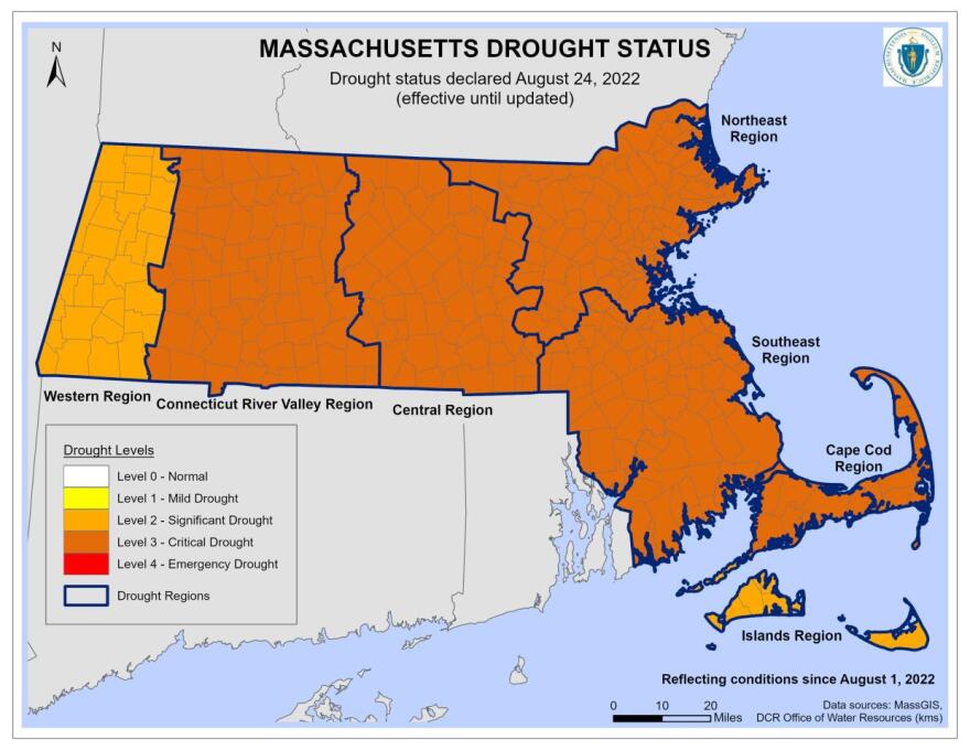
The severe drought gripping the region has significantly increased the risk of wildfire on the Cape, the Coast, and the Islands, the state’s top fire warden says.
Already this year, 110 wildfires on the Cape have burned about 20 acres total, but that relatively small number is largely thanks to the efforts of local fire departments. About a half dozen fires have burned from Falmouth to Brewster in the first half of August, alone.
“It's a heads-up that at any time, if the winds come up at the right time, if we get really good alignment of all of the factors that influence wildland fire, that we could get that really catastrophic or really challenging wildfire,” said David Celino, chief fire warden for the Massachusetts Department of Conservation and Recreation.
Celino said experts classify a wildfire as a blaze that burns one-tenth of an acre or more. People don’t often think of the Cape as being at high wildfire risk, Celino noted, but history proves otherwise.
“In 1938, there was a 3,000-acre fire in Sandwich that actually resulted in three firefighters that were trapped,” he said. “And there's a monument there on Route 131 dedicated to those firefighters that lost their lives.”
The region is prone to wildfires in part due to the kind of greenery found in some areas, he added.
“Especially on Cape Cod, with the pitch pine scrub oak fuel type, that is a very volatile fuel type. Some actually measure that as being the second most volatile fuel type in the country, and it’s second only to California's chaparral,” he said.
The Cape and Islands are also at risk because of population density in relation to the woodsiness.
“One of the things we're concerned about: 65 percent of our land, of our landscape [in Massachusetts] is in what we call the ‘wildland urban interface.’ And that's where the natural areas back up against settlement or development,” Celino said. “Cape Cod is a huge example of it down there where you have that volatile pitch pine backing up against developed subdivisions.”
Climate change, too, is increasing the frequency and intensity of droughts.
About 98 percent of wildfires in this state are human caused. One person’s unattended campfire or negligently discarded cigarette could create a massive blaze when combined with dry, hot, and windy weather and dried-out vegetation.
As a prevention tactic, this month the state implemented a temporary ban on all open flame and charcoal fires across the entire Massachusetts State Parks System.
But more is needed to avoid additional blazes.
“What we need now to come out of this is a tropical system,” he said. “We need roughly about nine inches of rain to bring us out of these drought conditions.”
Celino says about 880 wildfires have occurred statewide this year.


